Climate and environment updates: 7 key measures of Earth's health in danger, report warns

More than 75% of the planet's health and life support systems are in danger.

Last Updated: October 6, 2025, 9:43 AM EDT

The climate crisis is not a distant threat; it's happening right now and affecting what matters most to us. Hurricanes intensified by a warming planet and drought-fueled wildfires are destroying our communities. Rising seas and flooding are swallowing our homes. And record-breaking heat waves are reshaping our way of life.

The good news is we know how to turn the tide and avoid the worst possible outcomes. However, understanding what needs to be done can be confusing due to a constant stream of climate updates, scientific findings and critical decisions that are shaping our future.

That's why the ABC News Climate and Weather Unit is cutting through the noise by curating what you need to know to keep the people and places you care about safe. We are dedicated to providing clarity amid the chaos, giving you the facts and insights necessary to navigate the climate realities of today -- and tomorrow.

Sep 28, 2025, 4:21 PM EDT

Climate change is straining America's health care system: Study

Climate change is a public health emergency, driving heat, poor air quality, stronger storms, and new diseases that threaten people's health and strain health care systems, according to a new report from The Commonwealth Fund examining the impact of climate change on health and health care.

The report examined the preparedness of all 50 states and the District of Columbia to address rising health threats from climate change, identifying significant gaps in how health care systems respond to extreme weather, pollution and other climate-related risks.

The highest performers were Vermont, New York, Washington, New Jersey and Maine due to their clean energy policies, lower vulnerability to environmental hazards and lower greenhouse gas emissions. The worst performers were West Virginia, Kentucky, Louisiana, Florida and Mississippi.

However, the report makes clear that even the most prepared states need to do more.

"It's a mix for every state. There's no state that's at the top, "Matthew Eckelman, a professor of civil and environmental engineering at Northeastern University and report co-author, told ABC News. "What it tells us is that each state has some work to do."

Severe flooding in Frankfort, Kentucky, caused by days of heavy rainfall across the Midwest, April 7, 2025.
Leandro Lozada/AFP via Getty Images

Rising temperatures and more frequent, intense heat waves have become the deadliest weather hazard in the United States, accounting for nearly 250,000 additional deaths, according to the World Health Organization. Extreme heat disproportionately impacts older adults, outdoor workers, people with chronic conditions and low‑income populations.

According to the report, Nevada, New Mexico, and Arizona are the most vulnerable to extreme heat, with Arizona experiencing more than 140 days over 100℉ in 2024 and Nevada approaching 115 days.

Air quality is another growing concern.

Warmer temperatures and more frequent wildfires are leading to higher concentrations of ground-level ozone and particulate matter, both of which can exacerbate asthma, respiratory diseases, and heart conditions.

Smoke from wildfires — especially across the U.S. West — is now a significant health hazard and may be responsible for 200,000 excess deaths annually. Arizona and California had the worst air quality, while residents of Alaska and Hawaii can breathe the easiest with the cleanest air.

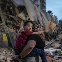
The report explains that extreme weather events such as floods, hurricanes, and storms can cause injury, water contamination and mental trauma.

These events often disrupt health services and basic infrastructure, compounding their long-term effects and jeopardizing the health of communities. Louisiana, Mississippi, and Florida stand out in this category, facing especially severe flood risks. The report estimates that nearly 15 percent of Florida hospital beds are located in high-hazard flood zones.

The health care system is not only at risk from these climate threats, but is also contributing to the problem, the researchers found.

More than 8.5% of the national greenhouse gas emissions originate from the health sector, with West Virginia, Wyoming, and North Dakota contributing the highest percentage per capita, according to the report.

And, while the report examines the national and state picture, weather events are also having a profound impact on local communities.

"Some disasters recently here in the U.S. have wiped out significant health infrastructure," Eckelman said.

Flooding in Western North Carolina wiped out some critical manufacturing facilities that supply life-saving medical supplies for the rest of the country, Eckelman explained. So, while the weather event only impacted one region of the country, it affected the supply chains everywhere, he added.

The authors of the report encouraged governments and health facilities to develop resilience plans and emergency plans so that they can continue operating during these events. They also challenged health care institutions to do their part.

"They can take a little bit of control over the emissions associated with their own operations and really abide by their mission to do no harm, not only through the care that they provide, but also in their behavior within the environment itself," Eckelman said.

- Dr. Tate-Drummer is a general surgery resident in the metro-Atlanta area and a member of the ABC News medical unit.

Sep 17, 2025, 2:39 PM EDT

Wealthy households are more likely to flee hurricanes and flooding than other households: Study

Extreme weather events can devastate communities. Now, a new study finds that it can also have long-term effects on a community's demographics that may hinder its ability to respond to future weather disasters.

The study from the University of Vermont, published in the journal Population and Environment, found that higher-income households left their communities at a higher rate than other households after hurricanes and damaging floods.

"Hurricanes had an impact on both net migration of people and net migration of income," said Mahalia Clark, lead author of the study.

The study examined anonymous IRS data from 2011 to 2021 to examine human migration and household income, and overlaid county-level data on weather-related property damage from data housed at Arizona State University.

"There hasn't been a ton of research that looks at how multiple different climate hazards affect human migration in the U.S.," said Clark. "There's even less on that migration's economic impacts."

In this Oct. 10, 2020, file photo, an aerial view of flood waters from Hurricane Delta is shown surrounding structures destroyed by Hurricane Laura, in Creole, Louisiana.
Mario Tama/Getty Images, FILE

Some regions experienced a different response to hurricanes and damaging flooding. The study found that the Northeast, for example, had fewer higher-income households leaving impacted communities.

"In the Northeast, we might be seeing those higher-income households being more responsive to this emerging threat," Clark said.

The study found that hurricanes had more of an impact on migration rates than other extreme weather events, but flooding had the highest impact on the income migration rates in affected areas.

"This suggests that you have either more higher-income households leaving, or fewer higher-income households arriving in those places," Clark said. "On average, the household income of the people leaving is higher than the average household income of people coming in."

-ABC News meteorologist Kyle David Reiman

Sep 15, 2025, 12:01 PM EDT

NOAA is using ocean robots to collect hurricane data

Forecasting hurricanes requires a lot of data. To predict when a hurricane will arrive, how strong it will be and where it's headed, meteorologists use sophisticated computer models that interpret measurements from the ocean and atmosphere.

Now, NOAA has another tool in its toolbox for collecting critical ocean information. In collaboration with the University of Southern Mississippi and robotics company Oshen, the agency has launched five small uncrewed surface vehicles.

The craft, called C-Stars, debuted on Aug. 31 by collecting critical weather and marine data off the coast of the U.S. Virgin Islands.

"Understanding weather conditions where the ocean surface meets the lower atmosphere is key to predicting hurricane intensity," said Greg Foltz, oceanographer and a lead principal investigator at NOAA's Atlantic Oceanographic and Meteorological Laboratory.

"If these miniature uncrewed surface vehicles prove reliable, they could become a critical piece of NOAA's hurricane observing system in the future," Foltz added.

NOAA is using a new robotic tool to collect hurricane data.
NOAA

The C-Stars are currently in a line extending from the U.S. Virgin Islands to Bermuda. The robots can be relocated to various oceanic regions to monitor different weather and marine conditions.

The C-Stars are wind-propelled with solar-powered sensors but are also equipped with electric motor thrusters for when the winds are weak.

The vehicles can operate individually or in fleets when covering a larger area. The C-Stars collect and transmit real-time data via satellite, including wind speed and direction, sea surface and air temperatures, air pressure and relative humidity.

"Although C-Stars have navigated storms with towering 24-foot waves, hurricanes are a whole new level of challenge -- but if it works, the long-term potential is huge," said Anahita Laverack, CEO for Oshen.

The C-Stars also collect wave condition information and can capture high-resolution images and videos, which can be retrieved when the craft returns to port.

"If these miniature uncrewed surface vehicles prove reliable, they could become a critical piece of NOAA's hurricane observing system in the future," Foltz added.

"We believe that these new, small USVs can move the needle in how we observe and understand hurricanes, while keeping budgets under control," Laverack added.

Lavarack told ABC News that the C-Stars are smaller, lighter, and cheaper to make and deploy than larger platforms, like the Saildrone that NOAA has used during previous hurricane seasons.

"Our size and platform cost allow us to field a constellation of many small robot C-Stars. In the future this could mean say 20 datapoints instead of just one within each hurricane, giving a richer understanding of the event," stated Laverack.

"We are excited by the role that C-Stars could play in improving hurricane forecasts, which have direct consequences for millions of people along the Gulf Coast," said Leila Hamdan, associate vice president for research and professor in the School of Ocean Science and Engineering at the University of Southern Mississippi.

-ABC News meteorologist Kyle David Reiman

Sep 09, 2025, 4:10 PM EDT

This summer was the 3rd-warmest on record for the Northern Hemisphere: Copernicus

The summer of 2025 (June to August) was the third-warmest on record for the Northern Hemisphere, surpassed only by the two previous ones in 2024 and 2023, according to new data analyzed by the Copernicus Climate Change Service (C3S).

Globally, last month also ranked as the third-warmest August on record, with an average surface air temperature of 61.88 degrees Fahrenheit.

While global air and sea surface temperatures are currently falling short of record highs, climate scientists warn this pause is unlikely to last as human-caused greenhouse gas emissions continue to fuel the long-term warming trend. Scientists anticipated a temporary decrease in global temperatures due to the recent La Niña event in the Pacific Ocean. This climate pattern usually results in a short-lived drop in global average temperatures.

People try to stay cool at the beach at Coney Island in Brooklyn as the region experiences another heatwave on July 30, 2025 in New York City.
Spencer Platt/Getty Images

The world's oceans remain warmer than average across the globe. Between the latitudes of 60 degrees south and 60 degrees north, the average global sea surface temperature was 69.48 degrees Fahrenheit, the third-highest value on record for August, according to Copernicus.

While the Atlantic Basin is currently quiet in terms of hurricane activity, unusually warm sea surface temperatures can play a key role in tropical cyclone development when more favorable atmospheric conditions return in the coming weeks.

In the polar regions, sea surface temperatures also frequently registered above average, negatively impacting sea ice. Antarctic sea ice coverage was 7% below average in August, ranking as the third-lowest value on record for the month. In the Arctic, it registered 12% below average, Copernicus said.

The Arctic region is warming much faster than the global average. After serving as a vital carbon sink for thousands of years, it has turned into a source of carbon dioxide emissions due to rapidly warming conditions and increasing wildfire activity, according to the National Oceanic and Atmospheric Administration.

-ABC News meteorologist Dan Peck

Sponsored Content by Taboola